

Navigating through Budapest has never been easier, thanks to Budapest GO, the official app designed to help locals and tourists move around the city seamlessly. From real-time schedules and ticket purchases to route planning, the app offers a range of features aimed at simplifying travel. But is it the perfect transit companion? In this article, we’ll explore everything Budapest GO has to offer, how to use it effectively, and what features it still lacks to become a truly flawless tool for commuters.
Public transports
Metro (Subway) – Budapest has four metro lines (M1, M2, M3, M4), showing their routes, stations, and connections, providing fast underground connections.
Trams – Popular tram lines like the scenic Tram 2 along the Danube and other key routes are marked on the map.
Buses – The app covers Budapest’s urban bus network, showing regular, express, and night bus routes, along with their stops and schedules.
Regional Buses – In addition to urban buses, regional buses extend transport services beyond Budapest, connecting nearby towns and suburban areas with the city center.
Trolleybuses – These electric buses mainly serve the inner districts of Budapest, providing an eco-friendly alternative for short-distance travel.
Suburban Trains (HÉV) – These regional rail lines link Budapest with nearby towns, making them ideal for commuters and day-trippers
Boats (Ferries) – Public transport boats on the Danube are integrated into the map, useful for scenic and practical travel.
Shared Bicycle and Scooter Services
MOL Bubi docking stations – Fixed stations where you can rent and return MOL Bubi shared bicycles for short trips across Budapest.

Mobi-points – Designated spots for parking and renting shared e-scooters and other micromobility vehicles in Budapest.
Understanding the Menu Below the Map
The menu located at the bottom of the map provides four essential options to help you to navigate and customize the public transport experience: Departures, Lines, Stops, and Filter. Each option serves a different function, making it easier to access relevant information quickly.
1. Departures
This option shows real-time departure times for public transport services. The departures displayed are based on the area currently visible on the map, whether it’s your current location or another part of the city you are exploring by zooming and panning. As you move across the map, the list updates to reflect the transport services available in the visible area.
Each departure listed provides key details to help users quickly understand their transport options. The information displayed on each departure includes:
- Transport type icon (metro, tram, bus, trolleybus, suburban train, or ferry).
- Line number of the arriving vehicle.
- Stop name where the vehicle will arrive.
- Distance from the user’s current location to the stop.
- Time remaining until the vehicle arrives at that stop.
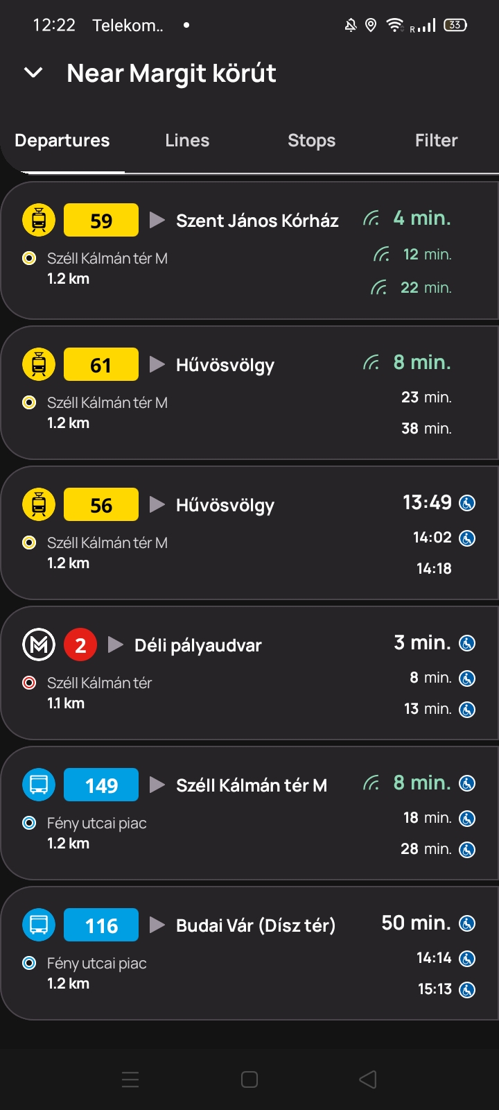
Additionally, if you tap on a departure, a detailed schedule appears, showing all upcoming times for that vehicle at the selected stop. This allows users to see the full list of scheduled arrivals and plan their trip accordingly.
💡 How it helps:
- See upcoming departures for transport services in the area you’re viewing.
- Check real-time updates while exploring different parts of the city.
- Easily find the next available vehicles at any location without needing to search manually.
- Tap on a departure to view the full schedule of that vehicle at the stop.
2. Lines
The Lines section shows a list of public transport route numbers that pass through the area currently visible on the map. As you zoom in or move across different parts of the city, the list updates dynamically to display only the lines operating in that specific section. The lines are also grouped by transport type, making it easier to navigate.
Additionally, if you tap on a specific line, the full route of that transport service will be displayed on the map, showing all its stops. This can help you visualize the exact path of the vehicle and determine the best transfer points or alternative routes.
💡 How it helps:
- Quickly check which transport lines serve the area you’re viewing.
- See grouped lists for metro, tram, bus, and other transport options.
- View the full path of a chosen transport line.
- Check if a specific line serves your destination.
3. Stops
The Stops section allows users to view public transport stops and stations in the area currently visible on the map. It helps locate nearby stops and check which transport services operate there.
Each stop or station listed contains the following details:
- An icon with a circular color code representing the available transport types (metro, tram, bus, trolleybus, suburban train, or ferry). If multiple transport modes are available, the circle is divided into corresponding colors.
- A small arrow indicating the direction in which the transport services are moving on the map.
- The name of the stop or station for easy identification.
- A list of transport lines, grouped by type, that serve the stop.
- A button to add the stop to favorites, making it quicker to access later.
- The distance between the user’s current location and the stop.
Additionally, if you tap on a stop, a detailed list of all upcoming departures from that location appears, sorted in order of arrival. This allows users to quickly check when the next available vehicles will arrive at that specific stop.
💡 How it helps:
- See which transport options are available at a particular stop.
- Easily find stops and stations in the area you’re viewing.
- Tap on a stop to see all upcoming departures in order of arrival.
4. Filter
The Filter section allows you to customize what elements appear on the map, making it easier to focus on specific transport options, ticket sales points, or useful city locations. The available categories include:
Public Transport
- BKK stops – Standard public transport stops in Budapest.
- Regional buses – Long-distance and intercity bus stops.
- MÁV trains – Locations of railway stations operated by MÁV.
Shared Bicycle and Scooter Services
- MOL Bubi docking stations – Locations where you can rent or return MOL Bubi bikes.
- Mobi-points – Designated areas for shared scooters and other micromobility services.
- Bicycle pumps – Public bicycle pump stations for quick maintenance.
Ticket Sales
- BKK Sales Points – Official Budapest transport ticket offices.
- Other ticket sellers – Additional locations where tickets are available.
Budapest Info
- POI – Attractions – Points of interest, such as landmarks and tourist sites.
- Drinking fountains – Locations where you can refill your water bottle.
- Public toilets – Restroom locations available to the public.
By enabling or disabling specific filters, you can tailor the map to show only the information they need, reducing clutter and improving navigation.
💡 How it helps:
- Show only relevant information by enabling or disabling specific filters.
- Reduce map clutter and focus on transport, ticket sales, or city services.
- Quickly find what you need, whether it’s a bus stop, bike station, or public toilet.
Planning a jorney
Use the search bar above the map to plan a route by entering a starting point and a destination. The results show multiple options, sorted by travel time, and include:
- Public transport connections, including necessary transfers.
- Color-coded routes based on transport type (metro, tram, bus, etc.).
- Real-time departure data to ensure accurate travel time estimates.
Once a route is selected, the full journey appears on the map, showing the exact path and your current location. Each segment of the route is clearly marked, making it easy to follow.
Buying a ticket
Purchase public transport tickets directly from the app using the ticket store. Choose from the available ticket options, then complete the payment digitally.
Once purchased, tickets appear in the My Tickets section. When boarding, simply validate the ticket by scanning the QR code at metro stations or showing it to inspectors on other transport modes. Additionally, you can view your ticket history to keep track of past purchases, and the app notifies you when a ticket is about to expire, ensuring you never travel with an invalid ticket.
Steps to Buy and Use Tickets
- Purchase tickets directly from the app.
- Choose from multiple ticket options, including passes and single tickets.
- Complete digital payments for a hassle-free experience.
- Access purchased tickets in the My Tickets section.
- Validate tickets by scanning a QR code or showing them to inspectors.
- Receive notifications when a ticket is about to expire.
- View ticket history to track past purchases.
Ticket Options
Different ticket types are available to suit various travel needs:
- Passes – Long-term options for frequent travelers:
- Monthly Pass – Valid for an entire month.
- 15-Day Pass – A flexible alternative to the monthly pass.
- Multi-Month Pass – Covers several months at a time.
- Single Tickets – For one-time journeys:
- Standard Single Ticket – Valid for a single trip. Multiple tickets can be purchased at once.
- Airport Shuttle Bus Ticket – Specifically for the 100E bus to and from the airport.
- Daily Travelcards – Unlimited travel for a set period:
- Available for 24 or 72 hours.
- Pest County & Hungary Passes – For travel bey
- Pest County Pass – Covers transport in the surrounding Pest County.
- Hungary Pass – Allows travel across the entire country.
Real-Time Transport Updates on Delays and Changes
Stay informed about real-time transport disruptions and route adjustments. The app provides alerts for:

Traffic congestion affecting arrival times, causing delays and requiring adjustments to your travel plans.
Temporary stop relocations due to construction or events, ensuring you find the correct boarding point.
Route diversions, indicating stops that are skipped and the new travel path, helping you navigate changes easily.
Service changes, such as schedule adjustments or reduced frequency, so you stay updated.
New stops added to existing routes, allowing you to take advantage of newly available connections.
Traffic changes can be found in the See Traffic Changes section under the More menu.
Favorites, Quick Access to Your Most Used Stops and Lines
Save your most-used stops and lines for easy access in the Favorites section. This feature allows you to:
- Mark stops and lines as favorites for quicker navigation.
- Check real-time departures instantly without searching.
- Easily find your preferred routes without re-entering details.
Keeping your favorites organized ensures a smoother and more efficient travel experience.
Frequently Asked Questions (FAQ)
How do I buy and use tickets?
You can purchase tickets in the Ticket Store, then find them in the My Tickets section. To use a ticket, scan the QR code at metro stations or show it to an inspector when boarding other transport.
Why can’t I see something on the map even though it’s enabled in filters?
If an item doesn’t appear, try zooming in on the map. Some elements only become visible at a certain zoom level.
How can I change the app language to Spanish?
The app is only available in English and Hungarian and does not currently support other languages.
Can I scan my purchased ticket’s QR code without an internet connection?
No, you need an active internet connection to validate your ticket by scanning the QR code. Make sure you have data or Wi-Fi before traveling.
Comments are closed.